
GPS-Based Fleet Tracking for Mines: How It Works, and Its Pros & Cons
Published 14 May 2026 · 7 min read
A GPS-based vehicle tracking system is the most widely deployed piece of fleet management technology in Indian opencast mining, and also the most widely misunderstood. It is genuinely useful, and it is genuinely limited. This article walks through both honestly.
In the layered taxonomy of mining fleet management, GPS / Vehicle Tracking System (VTS) sits at Tier 2, above manual radio-and-paper controls, below a full mining-grade FMS. It is the first technology layer most Indian mines deploy, often because tender specifications make it mandatory. Understanding what GPS-based tracking does well, and where it stops, is critical to deciding whether it is enough for your mine or whether you need to move further up the stack.
How a GPS / VTS Solution Works
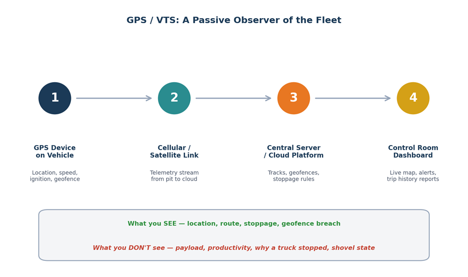
GPS-based fleet tracking is a simple telemetry pipeline. Each vehicle, haul truck, tipper, dozer, water tanker, light vehicle, carries a GPS device that transmits position, speed, ignition state and a handful of event flags to a central server, where the data is rendered into a live map and a set of stoppage, route and trip reports.
The four stages:
- GPS device on vehicle: captures location, speed, ignition on/off, geofence entry/exit, harsh-braking and overspeed events.
- Cellular or satellite link: carries the telemetry stream from the pit to a cloud or on-premise server.
- Central server / cloud platform: stores tracks, applies geofence and stoppage rules, generates alerts.
- Control room dashboard: renders the live map, plays back routes and produces trip-history reports.
What an SCCL-Style Tender Actually Specifies
SCCL has been issuing GPS-based VTS tenders consistently. The most recent example available in the public domain is the tender for the Naini Coal Mine in Angul, Odisha (mid-2025), which explicitly states the purpose as monitoring coal transportation trucks to prevent en-route pilferage[1]. For larger opencast projects, the SCCL OITDS specification goes further, listing requirements such as tracing and tracking of trucks, position and speed display, hour-meter capture, idleness alerts, equipment-status signal monitoring with warning generation, dynamic dumper allocation between shovels and exception notifications[2].
This is the floor of what “GPS-based FMS” means in the Indian PSU context. Most state-PSU and Coal India procurement specifications work off a similar baseline.
Pros and Cons of a GPS-Based Mining Solution
The single most important sentence about GPS/VTS in mining is this: it is a passive observer of the fleet, not a control system over it. That distinction drives both its strengths and its limits.
| Pros, what GPS / VTS does well | Cons, what GPS / VTS does NOT do |
|---|---|
|
|
When a GPS-Based Solution is Genuinely the Right Answer
GPS-based tracking is the right answer for mines whose primary problem is theft, route deviation or contractor accountability, rather than productivity optimisation. Specifically:
- Single-shovel or small multi-shovel mines under approximately 2 MTPA, where queuing losses are minor.
- Contractor-heavy operations where pilferage and route deviation are the dominant operational complaints, and weighbridge controls are already strong.
- Mines that need to comply with a tender-level VTS specification but are not yet ready, organisationally, for a Tier 3 or higher deployment.
- Operations using GPS/VTS as a deliberate first step on a planned roadmap toward a Tier 4 weighbridge-integrated FMS, see our trip count and dump yard tracking use case for how Tier 4 looks.
When GPS Alone is Not Enough
The clearest signal that you have outgrown GPS-only tracking is this: your operations team can describe where the trucks are at any moment, but cannot explain why today’s production was below plan. If your largest losses sit in queuing, NPT, payload variance or billing reconciliation, no amount of GPS upgrading will close them. What you need is payload monitoring (Tier 3), weighbridge and RFID integration (Tier 4) or real-time dispatch with automated queue management (Tier 5), depending on the loss profile. The components and outcomes guide covers what each tier delivers.
A useful diagnostic
Ask your dispatcher: “For the last full shift, can you tell me which truck made how many trips, what each trip weighed, and how much time each trip spent queuing versus loading versus hauling?” If the answer involves estimating from radio logs and weighbridge slips, you are at the limit of what a GPS-only solution can do for you. Our truck cycle time use case shows what closing that gap looks like.
Common Pitfalls When Deploying GPS in a Mine
- Buying Tier 2 GPS and then expecting Tier 3 productivity outcomes from it. The system was never built for those outcomes.
- Treating GPS deployment as a one-off IT project rather than the start of a multi-year fleet-visibility roadmap.
- Under-investing in dashboard discipline. GPS data is valuable only if someone in the control room is acting on the alerts and operators are seeing consequences.
- Ignoring connectivity gaps in deep pits, which create silent data blackouts and undermine trip-history reliability.
- Choosing a low-cost VTS vendor whose hardware is not mining-grade, leading to high device failure rates on dusty haul roads.
Bottom Line
A GPS-based vehicle tracking system is the right first investment for many Indian opencast mines, and a deliberate stepping stone for many more. It delivers real, measurable value in compliance, accountability and basic fuel discipline. What it does not deliver, and was never designed to deliver, is productivity optimisation, payload control or contractor billing accuracy.
The mines that get the most from GPS/VTS are the ones that deploy it with clear eyes: as a Tier 2 solution to a Tier 2 problem, with a plan to move further up the stack when their operational losses move past the categories that GPS can address. Talk to our team if you want to map the right starting tier for your operation, or explore MINEOPTIC Plus for analytics built for Tier 3 and Tier 4 deployments.
Sources & References
- SCCL Tender ENN25O0016, GPS/GPRS-based VTS for monitoring coal transportation trucks at Naini Coal Mine, Angul, Odisha (mid-2025). tendershark.com
- SCCL, Tender specification for GPS-based Operator Independent Truck Dispatch System (OITDS), covering tracing, position, speed, hour-meter capture, idleness alerts, dynamic dumper allocation and exception notification. scclmines.com
Continue exploring
Fleet Visibility Solutions Deployed in Indian Opencast Mines
The 5-tier framework actually deployed across Indian opencast mines, from manual controls to full OITDS-style dispatch.
Read blog →Typical Components and Outcomes of a Mining FMS
The four-layer architecture, eight capabilities to evaluate, and what real deployments deliver in practice.
Read blog →MINEOPTIC Plus
Multi-mine fleet & productivity intelligence with role-based dashboards for ops, maintenance and leadership.
Explore product →